 No thunderstorms detected..

About This Station
Lochaber Weather was setup in May 2016 and is located near Inchree, a village between Corran Ferry and Onich, close to Loch Linnhe, on the West Coast of Scotland.
The station was originally set up on the Isle of Lewis and ran as Hebrides Weather from 2007 until December 2015.
 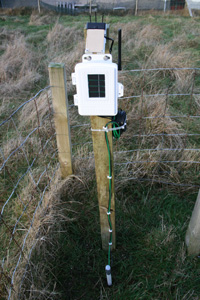 |
All the sensors are solar powered and have a battery backup. To stop birds from using the rain gauge as a toilet a row of stainless steel pin are arranged around the top of the rain bucket to stop birds from landing on the edge. The same has been done to the leaf wetness sensor. The soil temperature & moisture sensors have been placed at a depth of 20cm. There is a Boltek StormTracker Lightning detector connected to the computer using Nexstorm software that registers any lightning strikes within a 750 mile radius. The data for the lightning detector is also made available to various websites that produce triangulated lightning data to better identify the exact location of thunderstorms around Europe. The forecasts are created using WXSim software which is tailored to this location and collects data from various sources to produce an accurate 5-day forecast. The weather data is uploaded using a software called Weather Display which puts all of the data together, creates the graphs, tables and reports then uploads the data to the site. The program was written & designed by New Zealander, Brian Hamilton, who continues to update and add new features all the time. There are a number of other pieces of equipment associated with the website including a webcam looking at the Ardgour Hills, a Comar AIS-2-USB AIS receiver to see what shipping is in Loch Linnhe and a Kinetic SBS-1 virtual radar for picking up aircraft in the area. All the equipment is fed into a dedicated desktop PC which runs 24/7 and is fitted with an Uninterrupted Power Supply (UPS) which will supply enough power keep the PC and router running for about 40 minutes if the mains power is lost. |
  |
 The weather station in use is the
 About This Website
This site is a template design by CarterLake.org with PHP conversion by Ken True from Saratoga-Weather.org.
Special thanks go to Kevin Reed at TNET Weather for his work on the original Carterlake templates, and his design for the common website PHP management.
Special thanks to Mike Challis of Long Beach WA for his wind-rose generator, Theme Switcher and CSS styling help with these templates.
Special thanks also go to Ken True of Saratoga-Weather.org for a number of PHP scripts used on this website.
Template is originally based on Designs by Haran.
This template is XHTML 1.0 compliant. Validate the XHTML and CSS of this page.